17 December, 2023
Overall:
Ryan from FAT:
Welcome to the 5th season of this blog!
今日は日本語で書く時間がなかったので、このアプリケーションを使ってください。
This post is basically a summary of events consisting of my own observations with assistance from other guides.
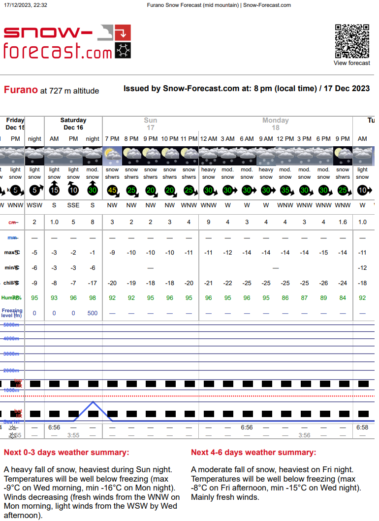
Currently it is -7C and snowing S2, about a rate of 2cm per hour, in the center of the Furano Basin at 191m. Light - Moderate NW winds.
Generally, there still isn’t enough snow for signifcant avalanches and the biggest hazard is certainly still half buried obstacles/ hazards beneath the surface. Still early season conditions although this is some of the best conditions in Japan apparently.. Most other ski areas S of Furano have experienced warmer temperatures and more severe rain events.
The early December rain event turned the base of the snowpack to meltforms, mostly destroying it completely below 400m. At my base in the center of the Furano Basin at 191m, the snow was entirely melted away to dirt. Above approxiamtely 700m, I noted there was still enough snow to ski in the trees after the following storm.
The following storm began before it had time to freeze in the vicinity of the ski area, causing it to bond reasonably well. Although this layer is obvious, I didn’t see much evidence of instability. There may be an elevation band above 1000m or an area near Furano where the bond isn’t as strong?
Last night, (20231217) the FL rose as high as 500m in Furano although it didn’t rain much as the forecast suggested (or at all?).. To the South in Mikasa and Sapporo, I hear it was much warmer and rained, further damaging the snowpack at lower elevations. In Furano, The FL then dropped early morning and snow fell throughout most of the day. I observed about 15cm of dense new snow accumulation by 14:00 at 750m, sheltered E aspect.
However, from now a lot of fresh snow is forecast overnight and tomorrow. I will be cautious around terrain traps such as many of the V shaped creeks in the backcountry that are still very open. There may also be some storm slab hazard at higher elevations and more likley wind slab on the higher E facing slopes.
Likley next update won’t come until next year. Hopefully then there will be more snow to talk about. It seems Furano is getting busy so please be respectful and look after eachother.
⚠ Always remember:
You are on your own out there. We assume no responsibility whatsoever.
You are on your own out there. We assume no responsibility whatsoever.